"Qalxalulhmtuhap"
- nwriversphotograph
- Sep 22, 2023
- 5 min read

Family Time! Bella Coola, British Columbia. 2023
Qalxalulhmtulhap means “We welcome you with an open heart” in the indigenous Nuxalk First Nation language. The Nuxálk traditional territories are located around the many inlets and valleys near Bella Coola, on British Columbia’s (BC’s) central coast, and I try to visit this special place as often as possible -- and have always felt welcomed by everyone I have met.

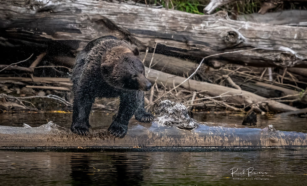
Shake It Off! Atnarko River, British Columbia. 2023
This area has so many of the elements I consider when I look to get away… an end of the road trip (Bella Coola is as far as you can go by car), a great drive with a wonderful valley at the end, wildlife, friendly-welcoming-and open hearted inhabitants, the only land route to the edge of the Great Bear Rainforest, and a ferry ride down the stunningly beautiful Discovery Coast. What more could you ask for?

It is also a prime habitat for both black and grizzly bears, and a few weeks ago my friend Kevin and I decided to go back up with our cameras and tripods and see what we could find during the fall coho and sockeye runs. We had been there together five years before, and we couldn’t wait to go back. This time, we would take a more circular route that would guarantee Kevin total immersion in some of the most scenic areas in the world – the magnificent Discovery Coast, Coastal Mountains, and the Pacific Northwest (Cascadia) region.

Roadside Black Bear! Bella Coola, British Columbia. 2023
Kevin drove from Boise to Bellingham (a little over five hundred miles each way), and then we took my truck and headed up for Kevin’s first experience with Vancouver, the Sea to Sky Highway, and the wonderful towns of Squamish, Whistler (with the Fitzsimmons and Garibaldi Ranges as a backdrop), Pemberton, and Lytton (confluence of the Thompson and Fraser Rivers). There are shorter routes, but really every mile of this has one beautiful vista after another. It is well worth the extra time.

Fisheries Pool! Atnarko River, British Columbia. 2023
We turned north up the Fraser River valley, then west along Route 20, the Chilcotin Bella Coola Highway, which ends at the five-thousand-foot elevation Heckman Pass where we started our steep descent into the Bella Coola Valley. As usual, we stayed with my friends Chris and Kristyn at the Nusatsum River Guesthouse in Hagensborg (just east of Bella Coola). They have some amazing cabins to rent, including a new cabin that we stayed at on this trip, and I highly recommend them. When we pulled in after our second day of driving, Chris had a fresh-caught salmon filet waiting in our refrigerator!
As usual for photography, we were up at five each morning and headed to the Atnarko River to look for bears (the Atnarko combines with the Talchako to form the Bella Coola River). We went prepared for rain, but the sun smiled down on us each day until we left the valley. A few powernaps during the afternoon and back to our cabin well after dark. The hours are exhausting, but when else do you get four days of just sitting along a river with your camera, a good friend, and spending time with bears?

Rockpile Pika! Bella Coola, British Columbia. 2023
One afternoon, just to see different scenery, we went up in elevation to my favorite rockpile to watch for pikas (family Ochotonidae). We joked about searching for the elusive saber-tooth pika that roamed the earth fighting off the great cats and Dire wolves. We didn’t see any of those; the pikas we saw were much cuter and super-fast. However, just talking about that had us continuously looking over our shoulders. That is until we fell asleep – it is really hard to stay awake in the sun, staring at rocks in your chair, and when you have been up since before first light.

King Island & the Burke Channel. British Columbia. 2023
Our last morning in Bella Coola found us in line by five in the morning to board the Northern Sea Wolf, the ferry that would take us down to Port Hardy on the north end of Vancouver Island. This is a ten-hour ferry ride (just under a hundred and nineteen miles) down the Dean and Burke Channels and then south along the Inside Passage to the northern tip of the Queen Charlotte Strait and Port Hardy. I’ve never been on a ferry ride that wasn’t wonderful, this one especially (my wife Stephanie and I took this up to Bella Coola some ten to fifteen years ago). But on this day, it was windy, cold, and grey – always expected along the PNW coast. So, while Kevin wandered about on deck, I enjoyed my second most exciting part of ferry travel – I slept for nearly the entire time!

Now, That's a Dinner! Atnarko River, British Columbia. 2023
The rain continued in Port Hardy, and now we were thinking about home. We booked it down Vancouver Island (another future trip destination) with brief stops in Port McNeill, Cambell River, and Nanaimo, then took the hour-and-forty-minute (thirty nautical miles) Ferry from Departure Bay to Horseshoe Bay in Northern Vancouver, crossing the border at Peach Arch and getting home late that evening. In all, over fourteen hundred miles of driving with another two hundred plus on the ferries (another thousand for Kevin).

Mother & Cub! Atnarko River, British Columbia. 2023
And what were the highlights? Well, a week in the car with my friend, followed closely by the bears and pikas, but really… every mile was fantastic, scenic, beautiful, and luckily for us, fire-free. There may be nowhere better to spend a week than doing this circuit through BC. I already want to go back!
Endnotes:
· Nuxalk Nation -- The term "Bella Coola" once referred collectively to the Nuxalk, Talio, Kimsquit and some Kwatna who inhabited villages around North Bentinck Arm and the Bella Coola Valley, South Bentinck Arm, Dean Channel and Kwatna Inlet. Their language is considered endangered today as there are likely under 20 fluent speakers. I’d like to share one of their stories on creation and the birth of their nation:
“Aalhkw’ntam, the Creator, created our first ancestors in the upper world, or heaven. He gifted them each with a spirit and breath and they came alive. He gave them names, technologies, and teachings to bring to the earth. He said, ‘Look to my walls of my house.’ Hanging on the walls were bird and animal cloaks (e.g., Raven, Eagle, Grizzly, Killerwhale). The ancestors wrapped these cloaks around themselves and transformed into the animal or bird before they descended to earth on the eyelashes of the sun, the sunbeams that hold up heaven.”
· A saber-tooth is any member of various extinct groups of predatory therapsids, predominantly carnivoran mammals, that are characterized by long, curved saber-shaped canine teeth which protruded from the mouth when closed. Saber-toothed mammals have been found almost worldwide from the Eocene epoch to the end of the Pleistocene epoch (42 million years ago – 11,000 years ago).
· The Dire wolf is an extinct canine. It is one of the most famous prehistoric carnivores in North America and roamed during the Late Pleistocene and Early Holocene epochs (125,000–9,500 years ago).


Comments